The ferry
Porto Santo Line runs the ship Lobo Marinho. The FAQ, read on 7 October 2026, says the trip lasts about 2h15. The same page says it leaves the south harbour of Funchal and the south harbour of Porto Santo, and that the ship takes 1153 passengers and 145 cars. Be at the passenger terminal no later than 30 minutes before departure. With a car, be at the garage one hour before. Cars, motorcycles, mopeds, quadricycles, jet-skis, and bicycles are carried. Each class has a fare on the Fares page. None of those prices is copied here. The FAQ says the price changes with the time of year, how many people travel, and how long they stay. A child up to 4 is free of the sea fare and still needs a ticket. Up to 11, the fare is half.
The company homepage says the island is 71 km from Madeira. From October to December the contact centre is open weekdays 9:00-19:00 and weekends 9:00-13:00 and 14:30-18:00, and closed on holidays. Phone +351 291 210 300, WhatsApp +351 962 025 500, infopsl@gruposousa.pt.
The October 2026 sheet uses the columns FNC/PXO and PXO/FNC. Under it: "Este horário pode ser alterado". On 7 October the row is Funchal 08:00 and Porto Santo 19:00. That pair is the usual one from 1 to 13 October. The sheet also shows two sailings on 2, 5, and 11 October, and an evening-only pair on 9 October, 18:00 and 22:30. 14 October is 06:00 from Funchal and a dash for the return. 15 to 22 October are dashes both ways. Sailings are listed again from 23 October. 26 October writes the return as 18h00. Diário de Notícias wrote on 1 October 2026, citing the company, that until the stop the crossing is três horas e 15 minutos. That figure is the newspaper. The FAQ still says about 2h15.
The November and December 2026 sheets use the same columns and the same warning. The common day is Funchal 08:00 and Porto Santo 18:00. Some days are a dash, including 10, 17, and 24 November, 2, 9, 15, 22, and 29 December, and 25 December. Some Fridays in November are only 19:00 and 22:30. 24 December shows a return at 12:00. 31 December shows a return at 11:30. Open the month before you buy.
The flight
Binter's page for Madeira to Porto Santo, read the same day, says the flight is 25 minutes, with flights daily in the morning and in the afternoon. It prints "a partir de 36,25€" next to the mobility subsidy. The fixed 36,25€, and 31,25€ for students, is written for residents of Porto Santo, on return tickets whose origin is Porto Santo. A general fare from Funchal is not copied here. The week's clocks are on Binter's timetable page.
On the island
Visit Madeira says the island is 11 km long and 6 km wide. Buses leave from beside the main service station, in the centre. The same page says they run daily to and from Porto do Porto Santo, where the ferry arrives and leaves, and that a tourist bus goes round the island once a day, about two hours. It prints no clock and no fare. Moinho Rent a Car's homepage says "Viaje em segurança nos nossos transportes públicos" and points CARREIRAS and HORÁRIOS at /transportes/. That address did not open on 7 October 2026. No bus time is copied here.
The taxi rank is by that service station. Visit Madeira gives +351 291 765 760 and geral@aitram.pt for the company that runs the taxis. No taxi fare is printed there.
The same page names Moinho Rent-a-car at Parque Empresarial do Porto Santo, lote 9, Sítio do Tanque, 9400-173, +351 291 982 141, moinhoreservas@gmail.com; Dunas Viagens e Turismo on Rua Dr. Nuno Silvestre Teixeira, 9400-172 Vila Baleira, +351 291 983 088; and Lazermar at Rua João Gonçalves Zarco 66, +351 926 700 471. It says several firms rent bicycles, and it also mentions cars, scooters, and quad bikes. It does not say which of the three rents the bicycles. On Moinho's homepage that day a Skoda Fabia was 70€ a day and a seven-seat Dacia Jogger was 120€ a day. The Jogger page also prints 110€ a day when the hire is two days or more. The car pages say the driver must be over 21 and have one year of experience.
A cycle path follows ER111 from Ribeiro Cochino to Praia da Calheta, almost 5 km, with gentle slopes. Cabeço da Ponta is four kilometres from the centre of Vila Baleira, and that beach has no public car park. Miradouro da Portela is at the east end, a little over a kilometre and a half from the centre. A distance from the harbour to the sand is not printed on these pages.
The beach and the water
Visit Madeira calls it a golden beach of 9 km along the south coast, with calm clear water. In 2022 European Best Destinations named it the best beach in Europe. The swimming page says the water is a little warmer than on Madeira, and that swell near the shore depends on the weather. Less experienced swimmers can find the entry hard. The same page says there are always calmer stretches. It does not print a wave height.
IPMA's beach page for Porto Santo, opened 7 October 2026, shows 7 Out through 16 Out and the columns Mar total, Ondulação, and Temp. Água, from the SWAN and ALADIN models. The heights are not copied here. The same day the warnings page listed Madeira-Porto Santo as Verde.
Portaria n.º 206/2026, in the Jornal Oficial of 13 May 2026, names the bathing waters and the praias de banhos, the beaches where lifeguards are present in the season. Article 2 says a bathing water that is not a praia de banhos did not have bather surveillance assured on the day the ordinance was published. The ordinance prints Cabeço da Ponta (PTMQ7P) as 15 de maio a 31 de outubro, Fontinha (PTMJ9M) as 15 de maio a 31 outubro, and Ribeiro Salgado (PTME8L) as 1 de maio a 31 outubro. Those three are the praias de banhos. Ribeiro Cochino (PTMQ9D), Calheta, Lagoa, Pedras Pretas, Penedo, and Porto das Salemas are printed as 1 de junho a 30 setembro, with a dash in the praia de banhos column. Calheta is also listed as a praia de uso limitado. On 7 October 2026 the three lifeguarded seasons were still open. The Ribeiro Cochino and Calheta seasons in that ordinance had ended on 30 September.
Visit Madeira says Praia do Ribeiro Salgado is a Praia com Bandeira Azul, in front of two hotels. Cabeço da Ponta, on that site, has a lifeguard, a rescue boat, and a first-aid post. Praia da Calheta is the southwest end of the nine kilometres, sand mixed with rock, with a car park, changing rooms, toilets, and a restaurant. Ilhéu da Cal is in that view.
Two viewpoints
Miradouro do Pico do Castelo is at 437 m. From it: part of the bay, the centre of Vila Baleira, Ilhéu da Cal, and Ilhéu de Cima. The page says you can drive up. It also describes a walk from the Camacha area around Pico do Facho, 516 m, of 3,2 km or 4,6 km. The PS PR 2 page, read the same day, starts the walk at Moledo, by the regional road, and gives 3,2 km in 1h30 or 4,6 km in 2h15. The box on that page lists the longer one: easy, 4,6 km, 2h15, Moledo to Miradouro do Canhão, 435 m / 225 m. The two pages do not name the same start.
Pico de Ana Ferreira is 283 m, the highest point on the west side. The prismatic columns are known as the piano. Visit Madeira says the place to look at them is Miradouro da Pedreira, near the Porto Santo golf club. Neither picture on these pages is that hill.
What the picture shows
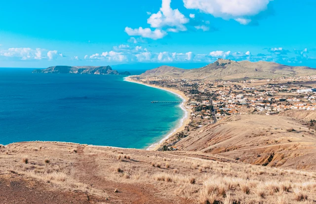
The picture on this page is the NetMadeira camera at Miradouro da Portela. Visit Madeira places that viewpoint at the east end, a little over a kilometre and a half from the centre, over the south coast, with Vila Baleira in the middle. The same page says Porto de Abrigo and the marina can be seen from there. On this page the airport is sometimes in the frame. The ferry queue is not.
The sand picture is Beachcam, at Ribeiro Cochinho beside Bar do Henrique. Ponta da Calheta is not in that frame.
Sources, read 7 October 2026
- Porto Santo Line, FAQ (English)
- Porto Santo Line, FAQ (Portuguese)
- Porto Santo Line, homepage
- Lobo Marinho timetable, October 2026
- Lobo Marinho timetable, November 2026
- Lobo Marinho timetable, December 2026
- Porto Santo Line, fares
- Porto Santo Line, contacts and hours
- Diário de Notícias, 1 October 2026
- Binter, Madeira to Porto Santo
- Binter, timetables
- Visit Madeira, getting around Porto Santo
- Visit Madeira, Praia do Porto Santo
- Visit Madeira, swimming on Porto Santo
- Visit Madeira, Cabeço da Ponta
- Visit Madeira, Praia da Calheta
- Visit Madeira, Miradouro da Portela
- Visit Madeira, Pico do Castelo
- Visit Madeira, PS PR 2
- Visit Madeira, Pico de Ana Ferreira
- Portaria n.º 206/2026, bathing season
- Moinho Rent a Car
- Moinho, the transportes address
- IPMA, Porto Santo beach forecast
- IPMA, Madeira-Porto Santo warnings
- Beachcam, the sand picture
- NetMadeira, the Portela picture
- The sand picture at Ribeiro Cochinho
- The picture from Miradouro da Portela
- The view
- The south beach of Porto Santo from Miradouro da Portela. The airport sometimes sits at the edge of the frame.
- Useful for
- See if the water below is already white with wind before you take the ferry.
- It will not show
- The ferry and the ticket queue are not in the picture.
- A plane on the ground is not an arrivals board.
- The camera
- Image by NetMadeira
- Getting there
- This viewpoint is not a beach entrance. The Porto Santo Line FAQ says the crossing is about 2h15. Open the timetable for the day.
Is the beach already windy before you take the ferry? The Porto Santo Line FAQ says the crossing is about 2h15. This picture does not show the boat.
This picture is Ribeiro Cochinho, next to Bar do Henrique. Not the boat, and not the far end of the beach. If the sand is blowing, the crossing will move.
This picture is the sand at Ribeiro Cochinho, next to Bar do Henrique. Not the ferry, and not the queue.
Shoes you can walk in, and something for the sun.
When to go
The airport sometimes sits in the corner of the frame. It will not tell you the flight is late. The ferry is not in the picture. The close view of the sand, by Bar do Henrique, is the other camera.
Portela is a viewpoint above the town side of the island. You do not walk out of this frame onto the sand. The harbour is down by the ferry. A walking time from the centre is not printed on these pages. A day trip is the morning boat from Funchal and the evening boat back. Miss the return and you are staying.
The airport sometimes sits at the edge of the same picture. A plane on the ground is not your departure time. The ferry itself never appears. For the sand at eye level, open the camera at Ribeiro Cochinho, by Bar do Henrique. That frame is one stretch of the 9 km. This one is the whole south shore from the hill.
The island is flat and short of shade. If the water is streaked and the sand looks soft, the afternoon on the beach will feel the same, even when Funchal is calm. Bring cover for the sun. The hill in the picture is not shade on the sand. Look before you commit to the crossing. Image by NetMadeira.
More beach and pool cameras on Madeira Island are on the Madeira beach live cameras page. Madeira beach live cameras
Porto Santo webcam from Miradouro da Portela over the 9 km beach. Check wind and sea before the ferry; the boat queue is not in frame.
A view from above, at Miradouro da Portela. The airport is sometimes in the picture. The ferry and the queue are not.
Porto Santo is often windy (trade winds); plan your trip.
Porto Santo (PXO) has a direct flight from Funchal. Self-transfer planner.
If the water is already white, the beach will be windy. The ferry time is a separate problem.
Miradouro da Portela looks along the south beach of Porto Santo, about 9 km of sand. This is the wide view. If the sea is streaked, the wind is up and a day on that flat shore is a poor use of a 2h15 ferry each way.
The airport sometimes sits in the corner of the frame. It will not tell you the flight is late. The ferry is not in the picture. The close view of the sand, by Bar do Henrique, is the other camera.
Portela is a viewpoint above the town side of the island. You do not walk out of this frame onto the sand. The harbour is down by the ferry. A walking time from the centre is not printed on these pages. A day trip is the morning boat from Funchal and the evening boat back. Miss the return and you are staying.
The airport sometimes sits at the edge of the same picture. A plane on the ground is not your departure time. The ferry itself never appears. For the sand at eye level, open the camera at Ribeiro Cochinho, by Bar do Henrique. That frame is one stretch of the 9 km. This one is the whole south shore from the hill.
The island is flat and short of shade. If the water is streaked and the sand looks soft, the afternoon on the beach will feel the same, even when Funchal is calm. Bring cover for the sun. The hill in the picture is not shade on the sand. Look before you commit to the crossing. Image by NetMadeira.
About this webcam
Quick facts
- Location: Porto Santo, Madeira
- Category: Southeast
- Best time to watch: All day; summer for the best sea conditions
- Coordinates: 33.0617, -16.3333
Weather Information
Madeira has a mild climate year-round. Use the webcams for real-time conditions (visibility, sea state, wind).
About the area
This page belongs to the Southeast category in Madeira and groups 10 related webcams. Use the category link to explore nearby views and compare conditions.
Quick Tips for Visitors
- Check local visibility and ocean conditions via the webcam before heading out.
- Madeira weather changes fast: bring a light jacket.
- Respect signage and local guidance.
Highlights
- 9km golden sand beach
- Calmer waters than Madeira
- Long shoreline
- Occasional airport in the frame
Nearby attractions
- Porto Santo town
- Boardwalk
- Island viewpoints
Travel tips
- Assess entry and swell before swimming.
- Bring sun protection and water.
- Respect flags and local notices.