📹Paul do Mar
Paul do Mar •Offline
Madeira Surfing Spots
A Village Beneath the Cliffs
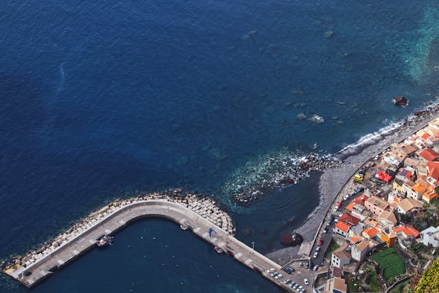
This isolated coastal community occupies a thin strip of land beneath towering vertical cliffs. For centuries, these natural walls isolated the settlement from the rest of the island, meaning fishermen had to rely solely on open-sea navigation. While the modern road network has made access much easier, the narrow village thoroughfare still gets quite busy early in the day. The local climate here is noticeably hotter and drier than the humid mountain ridges, though winds blow consistently. Afternoon temperatures rise sharply as the sun-baked cliff walls trap the heat, so dress accordingly.
You will notice the historic 1912 cannery ruins standing right at the edge of the shore. Volcanic activity shaped this rugged coastline fourteen million years ago, leaving large layers of dark rock that define the landscape. The small western harbor offers only limited protection for local fishing vessels, as sharp volcanic rocks line the sea floor, making it unsafe for larger boats. During high surf events, town barriers close the concrete ramp to prevent damage. A recent rockfall actually took out a section of the protective sea wall near the western harbor, and town workers frequently clear large boulders to keep the roads safe. Keep in mind that the primary access tunnel may close during heavy rainstorms to prevent accidents from overhead debris.
This isolated coastal community occupies a thin strip of land beneath towering vertical cliffs. For centuries, these natural walls isolated the settlement from the rest of the island, meaning fishermen had to rely solely on open-sea navigation. While the modern road network has made access much easier, the narrow village thoroughfare still gets quite busy early in the day. The local climate here is noticeably hotter and drier than the humid mountain ridges, though winds blow consistently. Afternoon temperatures rise sharply as the sun-baked cliff walls trap the heat, so dress accordingly.
You will notice the historic 1912 cannery ruins standing right at the edge of the shore. Volcanic activity shaped this rugged coastline fourteen million years ago, leaving large layers of dark rock that define the landscape. The small western harbor offers only limited protection for local fishing vessels, as sharp volcanic rocks line the sea floor, making it unsafe for larger boats. During high surf events, town barriers close the concrete ramp to prevent damage. A recent rockfall actually took out a section of the protective sea wall near the western harbor, and town workers frequently clear large boulders to keep the roads safe. Keep in mind that the primary access tunnel may close during heavy rainstorms to prevent accidents from overhead debris.
Our Team's Local Experience
We live just up the coast and drive down to Paul do Mar frequently. Because we know the microclimates here, we can tell you that when it is raining in Funchal, this corner of the island is often dry and sunny. We set up this camera so you can check the parking situation near Maktub Pub before driving down the steep cliff road. Our first-hand knowledge helps us keep this feed running despite the salty sea spray that regularly coats the lens.
Key Features
- •Check the real-time ocean swells before planning a surf session or coastal walk.
- •Check the parking and traffic situation along the narrow village promenade.
- •See the impressive Atlantic waves crashing against the concrete seawall.
- •See if the weather is sunny and clear before driving down the steep cliff road.
Highlights
- ✓The exposed concrete seawall and the rocky shoreline along the village.
- ✓Powerful Atlantic waves breaking over the shallow volcanic reef.
- ✓The narrow coastal road and available parking spaces near the promenade.
- ✓Local activity around the famous Maktub Pub and nearby fishing areas.
Paul do Mar Surf Conditions
Microclimate: Strong Western Basalt Corridor
- Notable coastal ribbon settlement compressed between towering 400-meter vertical cliffs and open Atlantic oceanic ocean swells
- Historical epicenter for elite deep-water surfing, demanding navigational precision due to shallow submerged reef shelves
- Is an immediate, unobstructed visual interceptor for incoming southwestern weather pressure drops before they impact the central mountain massif
- Historically isolated sea access requires constant real-time check of potential cliffside rockfall perimeters and coastal over-wash during peak winter tidal surges